Hiking Katahdin
There are some hikes that feel bigger than just the trail beneath your feet. For us, the climb up Mount Katahdin was one of those moments. We weren’t just hiking Maine’s tallest peak. We were seeing off a friend as they began their through-hike of the legendary Appalachian Trail.

Approaching Baxter Peak
Camping at Roaring Brook
The adventure began the night before at Roaring Brook Campground, where we tucked into a rustic lean-to. The night was cool and quiet, with the anticipation of the hike ahead keeping us awake as long as the rustle of the forest. It was the perfect staging ground, just minutes from the trailhead.
The Climb: Hunt Trail to the Summit
None of us had ever hiked Mount Katahdin, and heard it could take up to 10 hours, so we started early, when the air was crisp and cool. The Hunt Trail, the official northern terminus of the Appalachian Trail, greeted us with steady ascents that grew more challenging as we climbed. The last push to Baxter Peak was lots of bouldering and hand-over-hand climbing as the treeline gave way to sweeping alpine views.
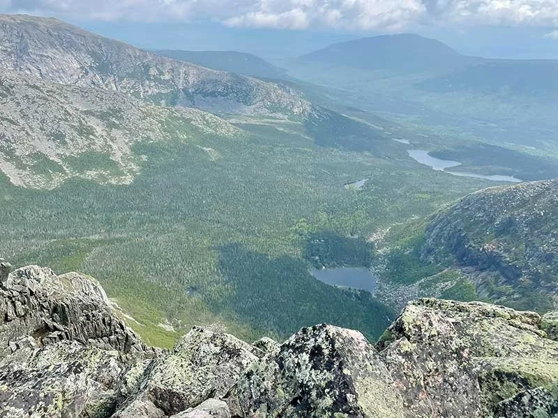
360° Views from Baxter Peak
The views from the summit of Mount Katahdin are nothing short of spectacular in every direction. From Baxter Peak, you’re treated to a 360-degree panorama that includes the rugged wilderness of Baxter State Park, the neighboring mountains, and on especially clear days, even the White Mountains of New Hampshire in the far distance. To the east, the dramatic Knife Edge trail stretches across the ridge, its jagged granite spine tempting the bravest hikers. Knife’s Edge was closed do to ice and snow this time around. Looking north, the endless forests and waterways of the Allagash River region and Aroostook County roll toward the horizon. And in every direction, the vast expanse of Maine’s unspoiled wilderness reminds you of the scale and beauty of this iconic mountain.
View from Baxter Peak
Abol Descent
From the peak, we descended via the Abol Trail. The route offered a different kind of challenge, steep in sections but rewarding with panoramic views of Baxter State Park. By the time we reached the bottom, the morning chill had long burned off, leaving us warm and exhilarated.
The Reward: Pizza & Beer
The hike took us a little over 6 hours, but can take longer depending on your skill level. After a day of pushing our limits, nothing felt better than unwinding at Knife Edge Brewing in Millinocket with pizza, local craft beer, and the satisfaction of a summit well earned.
Why Katahdin is Special
Perfect weather, great company, and a trail rich in both challenge and meaning made this a day to remember. For anyone planning a Katahdin hike, whether you’re chasing a personal goal, or like us, celebrating a friend’s journey on the Appalachian Trail, this mountain delivers an experience you won’t forget.

Keep Katahdin clean
Hiker’s Tips for Katahdin
Permits Required: Baxter State Park requires parking reservations for trailheads like Roaring Brook and Abol. Book well in advance during peak season.
Best Season: Late June through early October, when trails are snow-free and weather is most stable.
Difficulty: Katahdin hikes are strenuous. Expect steep sections, boulder scrambling, and exposed ridgelines.
Time Commitment: Most summit hikes take 6–10 hours round trip, depending on route and pace.
Gear: Bring sturdy hiking boots, layers for changing mountain weather, plenty of water, and high-energy snacks.
Safety Notes: The Knife Edge and summit boulder fields are exposed and should only be attempted in good weather. High winds, fog, or rain make these areas dangerous
After the Hike: Millinocket is the go-to spot to refuel, with local breweries and pizza joints welcoming tired but happy hikers.
👉 Ready to plan your own adventure? Explore more Maine hiking spots in Maine